Virtual borehole
November 5, 2024
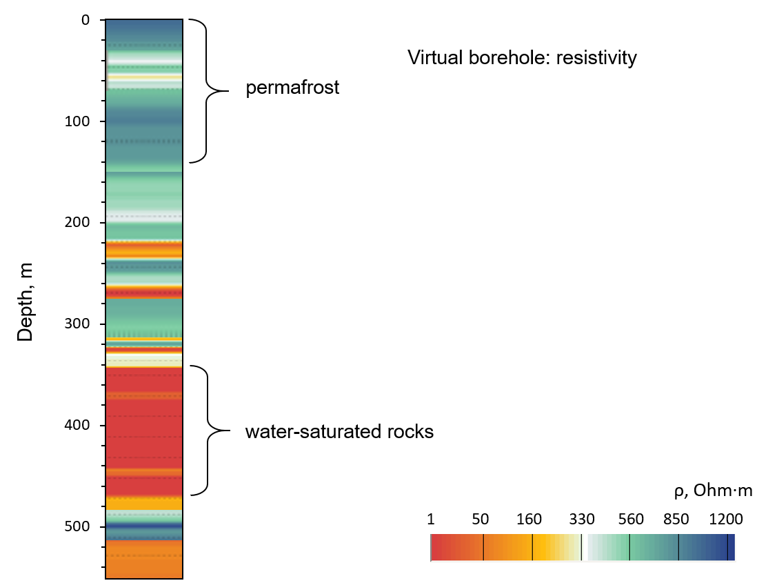
Virtual borehole in terms of the specific electrical resistance with marked intervals of permafrost and water-saturated rocks.
For use in oil and gas geophysics and solving geological problems at depths of hundreds of meters, the deep ground-penetrating radar method was significantly improved by Timer LLC in collaboration with leading experts from IZMIRAN and Shpilman Research and Analytical Centre for the Rational Use of the Subsoil. A breakthrough in informativeness in deep GPR research is achieved through special processing of data obtained during measurements with a changing offset distance between the transmitter and receiver, for example, using the common depth point method (ECDP).
The result of the study is quantitative: the values of electrical parameters recalculated from the velocity of the electromagnetic signal, determined on the basis of velocity analysis. The complexity of ECDP field work to a decrease in its productivity, compared to profiling, but this is compensated by the accuracy of determining the properties of rocks, the nature of the saturation of the reservoir, as well as high depth resolution.
The figure shows an example of determining the distribution of resistivity to a depth of more than 500 m in Eastern Yakutia, the so-called “virtual borehole”. Absolute effective values of resistivity are calculated with a step of 2-5 m, the positions of permafrost and water-saturated rocks correspond to geological data. In geocryological terms, the field site is located in a permafrost zone with a frozen rock base at a depth of approximately 150 m. The area has two tiers of frozen rock separated by a layer with reduced resistivity.
Verification of the obtained result was ensured by studying the field site using seismic exploration, electrical exploration and drilling.
Construction of a virtual borehole does not require the use of a priori structural models, unlike inversion methods used in electrical exploration, which is of great importance for increasing the reliability of geophysical models.
Considering the wide range of resistivity of rocks, a use of a virtual borehole is especially relevant for solving practical problems of identifying anomalies and objects with low-contrast electrical properties to the host rocks.
To conduct velocity analysis in electromagnetic sounding, it is necessary to use special equipment that allows high-speed linear recording of waveforms of reflected electromagnetic signals with the required duration of recording the wave pattern. We use innovative experimental equipment developed on the basis of GROT ground penetrating radar technology.
An absolute value assessment of the electrical resistivity based solely on deep ground-penetrating radar was obtained for the first time.
